The funniest and weirdest moments caught on Google Street View

Google Street View was first launched back in 2007, initially offering panoramic view points of just a few cities in the U.S.A. Nowadays, we can literally walk through the streets of not just cities, but even some of the remotest areas across the globe.

Some of you may have even appeared in Street View yourselves over the years when this car casually drove passed you:

With millions of streets to capture, it’s no wonder that every once in a while something weird and wonderful gets caught on camera!

Here are our weirdest and funniest moments ever caught on Google Street View!

1. Just a normal congregation of pigeon-headed humans on the outskirts of Tokyo, Japan. Not creepy at all.

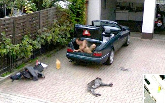
2. Planning his own kidnapping? Naked of course…

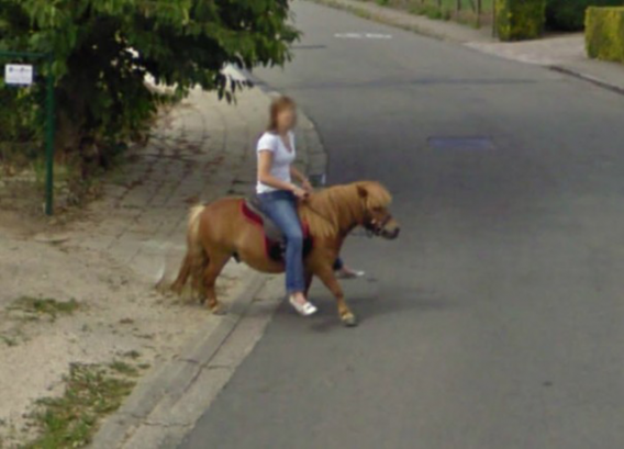
3. Just a full grown woman riding a tiny Shetland Pony. Giddy up!

4. Millions of childhoods wasted looking for this man, and Google manages to do it accidently. Where’s Waldo? In London apparently!

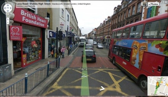
5. Good lord! Is that a tiger wandering through a parking lot?

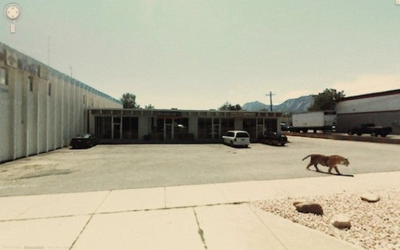
6. Just exactly how many drinks have you had sir?7. You’ve gotta love these guys… 
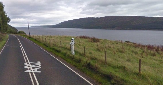
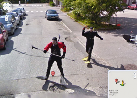
8. “The Stig” from British motoring TV show Top Gear, casually standing by the road next to Loch Ness, Scotland.
9. The guy on right is clearly sickened by the whole situation. 
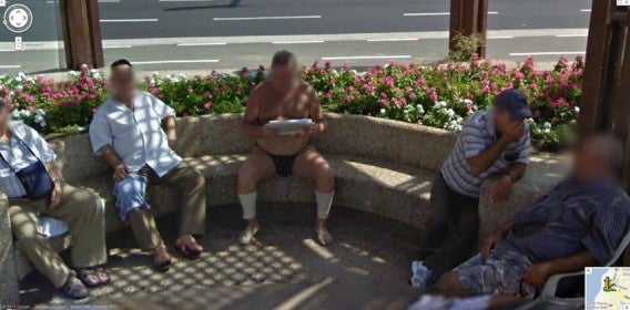
10. As if his day couldn’t get any worse, they had to go and get it on camera. 
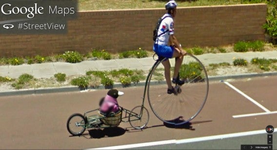
11. Casual bike ride around the block with your ridiculously-dated bicycle and your stuffed penguin.
12. You couldn’t have planned the timing any better. 13. Wait – did we go back in time?

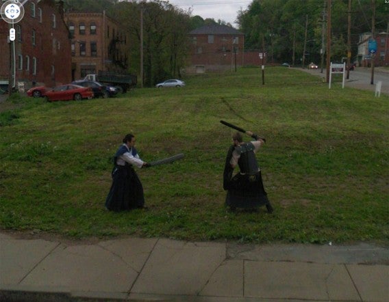
To keep up to date with all new features and additions on Google Earth, keep an eye on their YouTube page.

Google Street view gets a ‘time machine’

Google Street View was launched in 2007, and has been expanding all over the world ever since. Now the search giant has collected all its imagery from then until now, so you can travel through time in Street View.

In a blog post, Google Street View Product Manager Vinay Shet explained how they have added a clock icon to Street View images, which allows you to slide through the different images Google has taken of that place since 2007.

This means you can do things like see the 2014 World Cup stadium in Fortaleza, Brazil, or the Freedom Tower in New York being built. Vinay Shey also said that these historical images serve as records for recent history, like viewing earthquake damage and reconstruction. Depending on when Google took its Street View imagery, you can also use it to see the same place in different seasons.

Google Street view history is currently only available in the Chrome browser on desktops. Google has not said when this will be rolled out to mobile versions (or other browsers).

Source: Google Maps blog

RELATED STORIES

Turn Google Street View into a ‘The Last Of Us’ style apocalypse

Swedish developer Einar Öberg has created a site called Urban Jungle Street View, which uses Google Maps‘ Street View to make the world appear overgrown with vegetation, as if it had been abandoned by humans.

The site overlays trees, vines and other vegetation onto Google Street View, creating peaceful, but unnerving views of our world. To try it, simply visit the site, and search for any location with Street View, and you’ll be transported to a lush, forested version of the places you know. The site, an experiment by the developer, uses ‘depth data’ included in the Google Maps API to overlay sprites in ‘almost’ the correct position’ on the original image.

On his Twitter account, Öberg admits that he’s using the Google Maps API in a way that is not allowed by the terms of service, so it might not last very long if Google decides to take it down. That would be a shame, as Urban Jungle Street View is a neat experiment, and a fun use of Google Maps.

Visit Urban Jungle Street View.

Source: Twitter

RELATED STORIES

River Thames added to Google Street View

The UK’s River Thames has been added to Google Street View, becoming the first river in Europe to be mapped using Google’s technology. The map follows the Thames for almost 30 miles from Woolwich to Richmond, capturing 360 degree views of the river and the many iconic London landmarks that run along it.

The London Eye and Waterloo Bridge as seen from the Thames River


Palace of Westminster

Working with the Port of London Authority, Google UK strapped its Trekker Camera to the hydro graphic surveying vessel Yantlet to capture the images. The Trekker camera allows Google to capture images in areas that its Street View van and Trike can’t access.

Google Street View was first introduced in the US in 2007 and has since expanded to over 3000 cities in 53 countries, going beyond streets to let you inside restaurants and shops, ski resorts and slopes, and now, even taking you along waterways. The River Thames joins Antarctica and the Grand Canyon in Google’s quest to visually capture all corners of the world.