
 Google Maps has long dominated the navigation app world. It has been miles ahead for years with a whopping 67% of all navigation app users choosing the Google app in 2018. To put it into perspective, that is more than six times the number of people who used the second most popular navigation app, Waze, last year. Yes, you read that right, Apple Maps isn’t even the second most popular navigation app. Apple Maps comes in third with only 11% of navigation app users saying they used it regularly.
It isn’t just a numbers game either. Google has regularly been boosting its Maps app with new features and is even working hard to turn Maps into much more than a simple Navigation app. This feature-led domination could be about to slip, however, as Apple has recently submitted a new patent application for a very interesting navigation feature new Apple Maps feature.
AR Navigation is coming to Apple Maps
A recent report by Cult of Mac has unearthed a recent patent application from Apple regarding the Apple Maps app. The new technique, which Apple is calling “Navigation Using Augmented Reality” will require a driver to mount their iPhone on the dashboard of their vehicle in such a way that they can see the screen while the iPhone camera is able to see the road ahead unimpeded. If done correctly, the new feature could then revolutionize how that driver understands all subsequent navigation instructions.
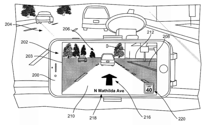
Traditionally, when we’re driving, we follow our GPS assisted navigation instructions via an overhead map of our current location. This typically includes directional arrows, and sometimes symbols that represent upcoming junctions and signs. The recently patented technique from Apple would do away with this and replace it with a live image of the road ahead overlaid with the navigation instructions telling us where to go next.

Warning: avoid these GPS navigation apps
Read now ►Apple believes this way of doing things would make following the instructions much easier for the driver. The patent application summary says, “By superimposing the navigational layer over the captured images, the user can clearly and easily understand which lane to be positioned in without having to decipher how general symbols correlate with the real world.”
Basically, it’s like a normal GPS map, but with the actual world in front of you as the map!
If you’re thinking that this sounds like the Google Maps AR navigation feature, we’ve reported on recently, you wouldn’t be wrong. Google Maps does already have an AR navigation feature. The key distinguishing factor here, however, is that the Apple Maps AR feature is designed for driving while the Google Maps feature only works for walking instructions.
Waze finally arrives for Apple CarPlay
Read now ►Wrapping up
As to whether this single new feature will be enough to turn users away from Google Maps, remains to be seen. It is good, however, to see innovation coming from Apple again with new and interesting features seemingly on the way to its core products.